Planning needs to be done now to address the future sea level rise in South Delta, say researchers that provided ominous visuals of what could unfold.
Current estimates have the sea level rise for South Delta at approximately 1.2 metres by 2100. However, at a science symposium in Vancouver on the weekend, a pair of researchers made a more dire prediction, contending the original estimates might be too conservative.
David Flanders of the University of B.C and Simon Fraser University professor of geology John Clague told a symposium for the annual convention of the American Association for the Advancement of Science that planning is needed for the possibility of a more rapid rise.
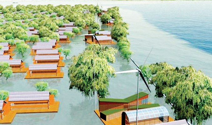
Using computer visualizations of rising sea levels in a low-lying coastal municipality like Delta, they illustrated ways to adapt to climate change impacts such as flooding and storms surges.
"To me, the visualizations are the only way that you can tell the complete story of climate change and its impacts in a low-lying coastal community," said Flanders, with the Collaborative for Advanced Landscape Planning (CALP), prior to the symposium.
"It can be hard to mentally grasp what rising sea levels can mean on the ground but our visualizations give people a glimpse of what their future world will look and feel like in their own backyards. They help community members understand how their quality of life can be affected by climate change, and by the decisions they make to deal with climate impacts," said Flanders.
Delta participated in the federally funded project, which shows what the community would look like if nothing is done.
"Combine the sea level rise with bigger storms, more wind, more waves and high tide and that's an enormous amount of water," said Flanders.
The images also showed scenarios under various strategies, including raising dikes, moving parts of the community out of the floodplain to higher ground and reducing vulnerability through design by raising homes, roads and critical infrastructure above the floodplain.
According to CALP, there's an urgent need for governments at all levels in Canada to make decisions concerning adaptation and planning strategies.
Noting planning is already well underway on how Delta can deal with a 1.2-metre rise in sea level by the end of the century, deputy engineering director Hugh Fraser said current estimates are based on information from government and scientists.
"I'll leave the debate for the scientific community. We take the information from the province and they're talking one to 1.2 metres. The multi-metre (rise), I think, is on the extreme outside, but we just don't know at this point," he said.
Noting South Delta is also settling, Fraser said, "There's been a number of things that we've done as far as preparation. First of all, there's things on the planning side and those are ongoing activities. There's water level measurement to see how realistic it is and how much it is relative to Delta. You need long-term data for that and we don't have sufficient longer term data yet to establish trends."
Fraser noted that worldwide there are significant differences and predictions for sea level rise.
"It's very interesting to see how much is localized. In some areas, there's no sea level rise happing. A matter of fact, in some areas the land is rising faster than the sea, whereas in other areas, like Delta, we expect we'll be seeing a gradual rise, while in other areas there's significant sea level rise that's been documented."
Delta's location on the Fraser River floodplain puts the community at risk of flooding. Currently, the main flood threat for Delta occurs from winter storms and also along the Fraser River in the late spring and early summer, particularly when there's a heavy snow pack and a sudden spell of warmer weather.
South Delta's two major floods, in 1894 and 1948, were both a result of the spring freshet.
Delta's dike system is constructed to what's described as a 200-year flood level, which means the risk of flooding is estimated to be 0.5 per cent in a given year. That means there's is a 99.5 per cent chance that flooding from high water will not occur.
What's not clear is how the current dike system would hold up with rising sea levels due to climate change by 2100, but it's obvious with the computer images there needs to be upgrades.
The provincial government last year released a report on how rising sea levels will affect coastal B.C. over the next century, stating the obvious: Delta has a high risk and consequences of flooding.
Fraser, noting a number of works to dikes and pump stations have already been done, said upgrades would be gradually carried out as funding becomes available.
He said the province is also undertaking a study to look at the costs of improving the coastal flood protection system.
"Then, obviously from a long-term funding perspective, they're going to have to think how they are going to work with the feds and local jurisdictions to start implementing some of these measures," Fraser added.
Also noting preparations and planning are underway, as well as ongoing funding requests for dike upgrades, Coun. Scott Hamilton said Delta is well aware of its vulnerability.
He pointed out some of the diking system in South Delta is also a Metro Vancouver responsibility.
The government last year also released a report that had new maps and guidelines on areas deemed the most vulnerable by the end of the century.
The report, Coastal Floodplain Mapping Guidelines and Specifications, identifies new engineering requirements that'll be needed for establishing building elevations in coastal areas.
The information is to help urban planners and local government officials incorporate rising sea levels into flood-hazard area land development decisions, such as official community plans, zoning, subdivisions and building permits.


