It’s going to be more than just high-rises in a redeveloped part of Delta.
The Parks Recreation and Culture Commission this week discussed a consultant’s comprehensive report that outlined potential scenarios to change the Townline Node neighbourhood, located in the northeast corner of North Delta near the intersection of Scott Road and 96th Avenue.
Often referred to as “the triangle”, the area is bounded by the City of Surrey to the north and east, the railway line to the west and 92nd Avenue to the south.
The long-term plan is to encourage redevelopment, changing it from industrial and service uses to a residential neighbourhood with mixed-use buildings along Scott Road.
It’s anticipated that the plan will accommodate up to 2,200 new residential units with a range of heights including a few high-rises.
The report looked at not only possible residential developments schemes but layouts for green, open space as well, noting access to such spaces is especially important in high-density developments.
The committee in particular looked at the conceptual design and implementation strategy for a new local park and 119B Street greenway.
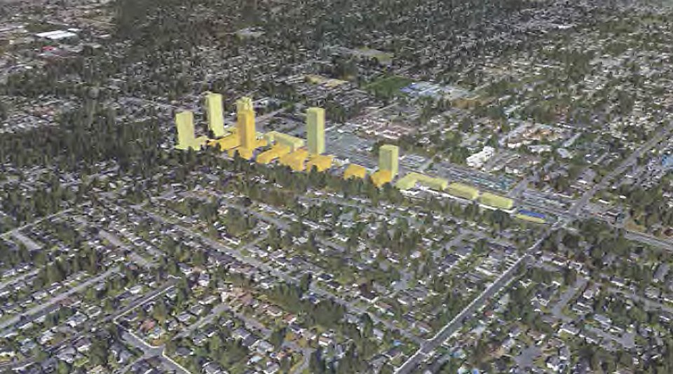
Development scenarios are being considered for the Townline Node
“A new park within the area for easy access by residents, and especially households with children, is essential to residential livability with a playground as its key feature. A local park within the Townline node should be within close walking distance of all residents and accessible without having to cross a major roadway or, by using the 1198 Street greenway, a local Avenue,” the report notes.
“The existing 119B Street is intended to continue to provide local, slow vehicular access while becoming a greenway with continuous, uninterrupted walking and cycling in both directions along the railway corridor. It will fulfill a section of the north-south bicycle route identified in the Official Community Plan policies. Located on the west side of the right-of-way, it will not encounter either road or driveway interruptions within Townline.”
There are a range of potential park locations that depend on future applications, the report notes, adding the local park could be located on a site acquired by the city or, alternatively, the park location could utilize a city road right-of-way
Other open spaces that could be part of the redeveloped area include a children's play area, ample and varied outdoor seating opportunities, trees for shade and contact with nature, tables and infrastructure for outdoor eating, a stormwater feature/natural planting area and community garden area.
Currently going through the various civic committees, the new neighbourhood vision will be undergoing refinement before going back for more public consultation, and a final report then provided to council.


